OC may never be the same.
Addendum: November 2005 Bayside
America has been built, golf course, houses, shopping center...
Why should Ocean City Maryland care about what their neighbor
does just a clam's shell skip to the north?
What are the plans for North Ocean City Parking and access to Ocean City Maryland via Route 54.
Will the Americana Bayside now named Bayside America, project and the influx of people into
Ocean City Maryland congest North Ocean City's back streets with traffic?
Attempts are continually made to divert traffic off of Route 54 from traveling
through Caine Woods and or up and down 146th and 142nd Streets?
How and when will Route 54 be reconstructed to handle traffic at the Coastal
Highway intersection that is extremely prone to accidents, and very very
serious accidents occur at that intersection every year.
Will Delaware and Sussex County provide public transportation up
and down Route 54 and will those buses be expected to dump passengers
on to Ocean City streets... Who will pay for the new cross walks, skyway walkovers, street lights and
crossing lights that will have to be made to accommodate the influx of pedestrians?
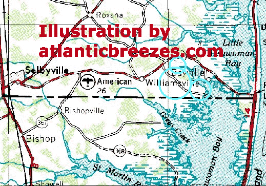
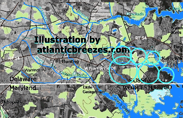
Bayside America initially wanted a projected 2,900 homes, golf course, shopping center and other amenities
to be built in the locations shown on the maps below. The Sussex County council approved the plans for
1,700 homes that didn't please Americana Bayside.. the final tally for the total number of homes to be built
has yet to be determined, and it must be remembered, this is just for one project, at that location, and does not
take into consideration any other spin off developments that are underway and will be constructed in the future that will impact the beach and close proximity of the beach. It has been a proven fact that Bethany Beach is a total mess with traffic. Bethany hardly has a beach that can accommdate the influx of building. Rehoboth traffic problems along the outlet corridor is further proof of Delaware's inability to forsee the impact of building and development.
Many current problems exist... that have hardly been addressed or resolved...
What will be the environmental impact of American Bayside into Maryland's Coastal Bays?
Immediate runoff into the the north end of Assawoman bay, does Delaware lack of a similar program
like the Maryland Coastal Bays Program to help instruct and guide proper
land use in coastal areas in Delaware?
How has the total and long term impact of an area that is basically swamp land,
been taken into consideration?
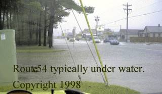
The water table is extremely high, and the land is just barely above sea level.
It is a proven fact that the sea level is rising, will the Federal Government
be expected to bailout the speculative nature of this occurrence, just like the
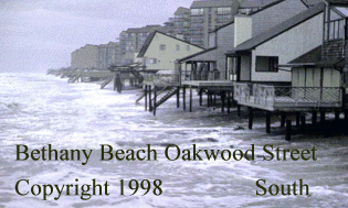
government is bailing out the speculative building on the dune lines along the coastal
areas of Maryland and Delaware? Since this area is proven to be prone to flooding,
does this area qualify for Federal flood insurance... and if so, why?
Should the government be expected to bailout projects that have a high propensity
to unavoidable acts of nature...
 Above is an example of Freeman Associate's, Bayside America, conceptual builders, that the government has to bailout with sandpumping that you pay for with your Federal monies, even if you live in Iowa. |


From the Worcester County Department....
Background
Floodplains (lands subject to flooding) are often described in terms of flood frequency. A 100-year flood refers to a flood with a 1% possibility of occurring in any given year. There are financial and social burdens associated with flooding that should be considered when building within floodplains. The coastal zone is constantly changing. Sea level rise and sinking of land causes coastal lands to become slowly inundated, and the area of land flooded or subject to flooding migrates landward. Roads and structures within a floodplain generally reduce the capacity of the floodplain to absorb flood waters, thus increasing the size of the floodplain and the duration of a flooding event. In other words, floodplains change both because of natural "aging" and human activity -- thus new areas may become prone to flooding over time. Landowners may determine whether land they own falls within a mapped floodplain by inspecting FEMA floodplain maps, available at the Department of Development Review and Permitting.
Laws, Regulations and Programs
The Worcester County Floodplain Management Law applies to development in both tidal and non-tidal floodplains. The law is consistent with the minimum requirements of the National Flood Insurance Program, and requires that new structures within the floodplain meet certain flood protection measures. For more information about these requirements, you may contact the Building Division of the Department of Development Review and Permitting. The Worcester County Forest Conservation Law requires that forests located in the 100-year floodplain are to be considered "retention priority areas" during the development process. More information about this law may be obtained at the Department of Development Review and Permitting.
Since Americana Bayside backs directly up against Ocean City Maryland's Coastal Bays... does the project meet or coincide with Worcester County's and Maryland Coastal Bays guidelines for wetlands and dredging...Background
Wetlands are generally areas that are temporarily, seasonally or always inundated or saturated by water. Wetlands are identified by their hydric soils, and plants that are adapted to wet conditions. Functions of wetlands include, but are not limited to, fish and wildlife habitat, food chain support, storage of flood waters, erosion control, groundwater recharge, nutrient cycling and storage, and pollutant removal. Worcester County contains extensive wetland areas of varying types performing diverse functions.
Laws, Regulations and Programs
Development and other activities in nontidal wetlands are regulated by the Maryland Department of the Environment (MDE) and the U.S. Army Corps of Engineers (USACOE). Nontidal Wetlands of Special State Concern often contain rare or endangered species, and are designated for special protection under the State's nontidal wetlands regulations, including increased buffering requirements. Maryland Nontidal Wetland Guidance Maps identify the general locations of wetlands, including those of Special State Concern, in Maryland, and may be viewed at the Department of Development Review and Permitting. These maps were created for regional-level planning, and are only suitable for general guidance for the individual landowner as they are based upon aerial photograph interpretation. Many more wetlands exist than are mapped. Wetland delineation at any specific site requires an on-site study by a qualified consultant.
Dredging, filling and other alterations to tidal wetlands are also regulated jointly by MDE and the USACOE. Tidal Wetlands Inventory Maps (1971) and on-site study are used for determining the boundaries of tidal wetlands that are regulated by the State of Maryland. These maps may be viewed at the Department of Development Review and Permitting. Copies of these maps are available for a fee from the Maryland Department of Natural Resources, Geological Survey Publications Office. Tidal wetlands within the Chesapeake Bay Critical Area are protected under the more stringent requirements of the State Critical Area Program. The boundaries of the Worcester County Critical Area may be viewed at the Department of Development Review and Permitting. Storm water management and sediment and erosion control measures also protect wetlands.
Does the American Bayside Project conform to Worcester County's and Maryland Coastal Bay's Storm water Management Guidelines?" Storm water management protects the water quality of the Coastal Bays, the County's wetlands and other waterways as well as reduces local flooding and stream channel erosion. Effective sediment and erosion control during the development process provides protection both to land and to water bodies including the Coastal Bays. Worcester County law states that any clearing or grading is subject to the County's Sediment and Erosion Control and Storm water Management Regulations. However, there is a blanket exemption for minimal disturbance under both laws. An applicant must submit a Storm water Management Plan and a Sediment and Erosion Control Plan to the Worcester Soil Conservation District for approval. (Depending upon the nature of the project and size of the parcel, the Worcester Soil Conservation District may recommend that the storm water management requirements be waived; waivers are granted by the Department of Development Review and Permitting.) Storm water Management Plans are valid for a period of one (1) year; while Sediment and Erosion Control Plans are valid for a term of two (2) years. More information on these requirements may be obtained by contacting the Department of Development Review and Permitting."
